From saints to sinners, medieval priests to ancient stones, poets to smugglers – the Isle of Wight is steeped in folklore, history and legend.
Discovering the local stories behind our landmarks adds to the joy of discovering the beating heart of the Island. Read our guide to the most beautiful, the most famous and the most interesting landmarks on the Isle of Wight and see how many you have visited…
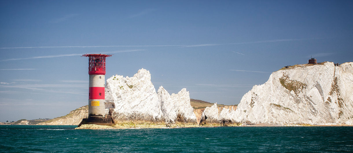
The Needles
Absolutely iconic, the image of The Needles can be seen in every souvenir shop and is known the UK over. But how many know the history of the distinctive rocks rising off the west coast of the Isle of Wight?
The Royal Geographical Society has recognised The Needles as one of the seven wonders of the UK. The Needles form a row of three distinctive chalk stacks looming out of the rough waters close to Alum Bay on the western peninsular of the Island.
Originally four stacks, the formation is actually named for the lost rock, which dramatically collapsed in 1764. This rock was ‘needle’-shaped and known as ‘Lot’s Wife’ after the ‘Pillars of Salt’ story from the Bible. Its collapse during a ferocious storm was apparently felt (and maybe even heard) as far away as Portsmouth and left the gap in the formation you see today. The name stuck – and that’s why The Needles don’t really look anything like needles!
The red and white lighthouse is set in the base of the rock furthest out to sea and began its duties in 1859, taking over from the original lighthouse on the cliff which was considered useless due to its high level and poor visibility. The lighthouse was automated back in 1994 and can be seen up close and personal from boat trips operating from nearby Yarmouth and at Alum Bay.
At the top of the cliff, you’ll find The Needles Landmark Attraction - a pleasure park complete with an amusement park, shops and rides. Take the scenic route down to the shore onboard the chairlift from the park to the coloured sands of Alum Bay.
You can get a spectacular view of The Needles from The Old Battery, a fortification set atop the cliffs. Originally built to guard against the French in the 19th century, it was used against the Germans in the 1940s. Nearby on the High Down, there’s another National Trust military relic - The Needles New Battery – a former rocket testing site which houses a museum and cafe with a view.
(1).jpg)
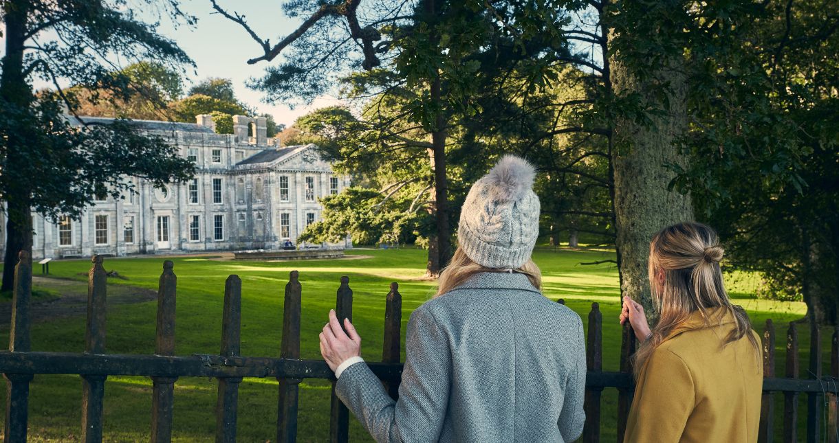
Osborne House
One of the most iconic landmarks on the Isle of Wight, Osborne House is a must-visit for anyone exploring the Island. This former royal residence was the beloved home of Queen Victoria and Prince Albert, offering a fascinating glimpse into the life of Britain’s longest-reigning monarch. Set in 360 acres of beautifully landscaped gardens with stunning views over the Solent, the house is a masterpiece of Victorian architecture.
Step inside to discover beautifully preserved rooms, including the grand Durbar Room, where Queen Victoria held private audiences, and the stunning Swiss Cottage, built by Prince Albert for the royal children. Stroll through the lush gardens, enjoy panoramic views of the coastline, and explore the grounds, which include a private beach and woodland walks. A visit to Osborne House is not just a journey into the past but also a celebration of the grandeur and elegance of the British royal family. It’s a perfect landmark to experience the rich history and heritage that make the Isle of Wight so special.
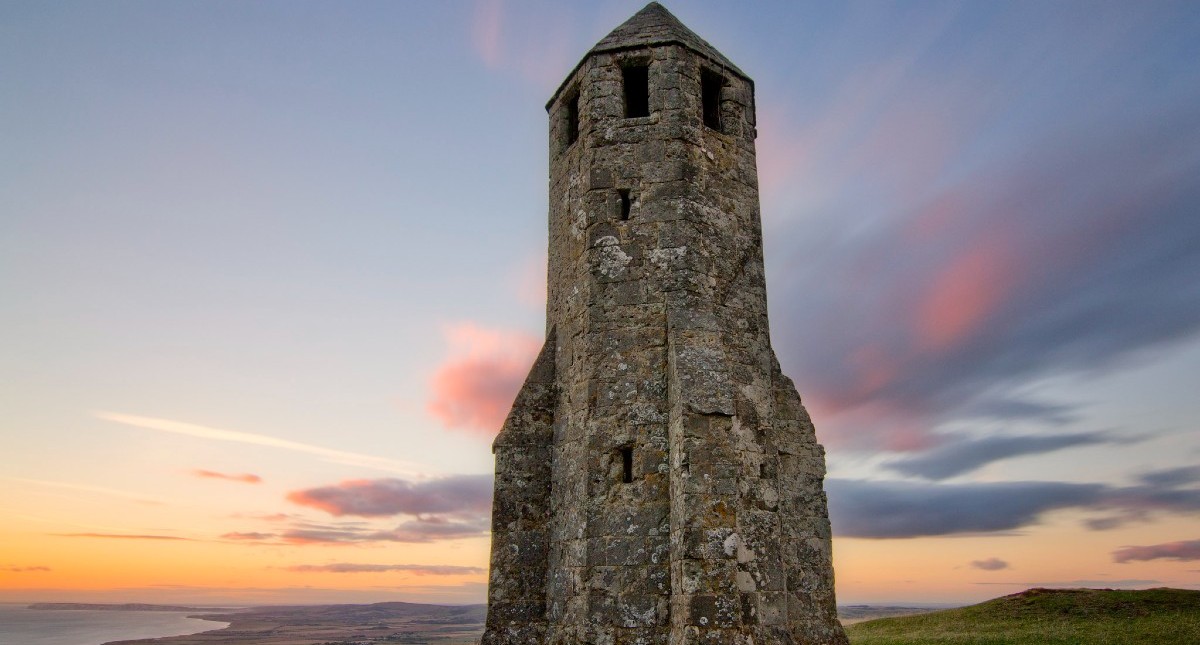
St Catherine’s Oratory
The only surviving medieval lighthouse in England, St Catherine’s Oratory, or the Pepperpot as it’s known to locals, stands on one of the highest parts of the Island, on the southern coast of the Island on the outskirts of Chale.
The 11-foot tall stone tower is all that remains of the original building and was built by Walter de Godeton, former Lord of Chale, as a penance for stealing wine from a ship that was wrecked in Chale Bay in 1313. Threatened with excommunication from the church, Walter chose instead to build the lighthouse on St Catherine’s Down and employ priests to pray for the souls of his family, himself and sailors at sea. The lighthouse was consistently manned until Henry VIII decommissioned it during his Dissolution of the Monasteries in the late 1530s.
The tower’s arched door heads suggest that it was still of interest in the late 16th century as it was extensively repaired around the time of the threat from the Spanish Armada in 1588. In the 18th century, Sir Richard Worsley of Appuldurcombe House added four large buttresses to prevent the tower from collapsing (giving it its unique rocket-like appearance!)
Standing at four storeys high, the octagonally shaped tower is well preserved and it’s possible to see the remnants of the walls of the rest of the original building. You can also see the foundations that were laid for a replacement lighthouse in 1785 nearby – affectionately referred to as the ‘Salt Cellar, which was never completed.
Easily accessible by footpath you can climb up to the top of St Catherine’s Down from the path at the end of Upper House Lane in Chale. There is a fab viewpoint car park just below the start of the path, where you can grab a cuppa and an ice cream upon completion of your walk.
Hoy Monument
You can extend your walk from the Pepperpot to one of the Island’s lesser-known landmarks - The Hoy Monument.
This 72ft tall column with an orb on the top, was previously known as the Alexandrian Column and was erected in 1814 by Michael Hoy who was a notable Island and City of London figure. In 1812 he was made a Sheriff of the City, and locally he owned much property, including The Hermitage in Ventnor and over 1,700 acres. The monument was built to commemorate a visit by His Imperial Majesty Alexander the First, Emperor of all the Russias to Great Britain, but he only ever made it as far as Portsmouth so never actually saw it. It was later extended to commemorate the Crimean War.
The monument is owned and maintained by Chale Parish Council. It was restored in 1992.
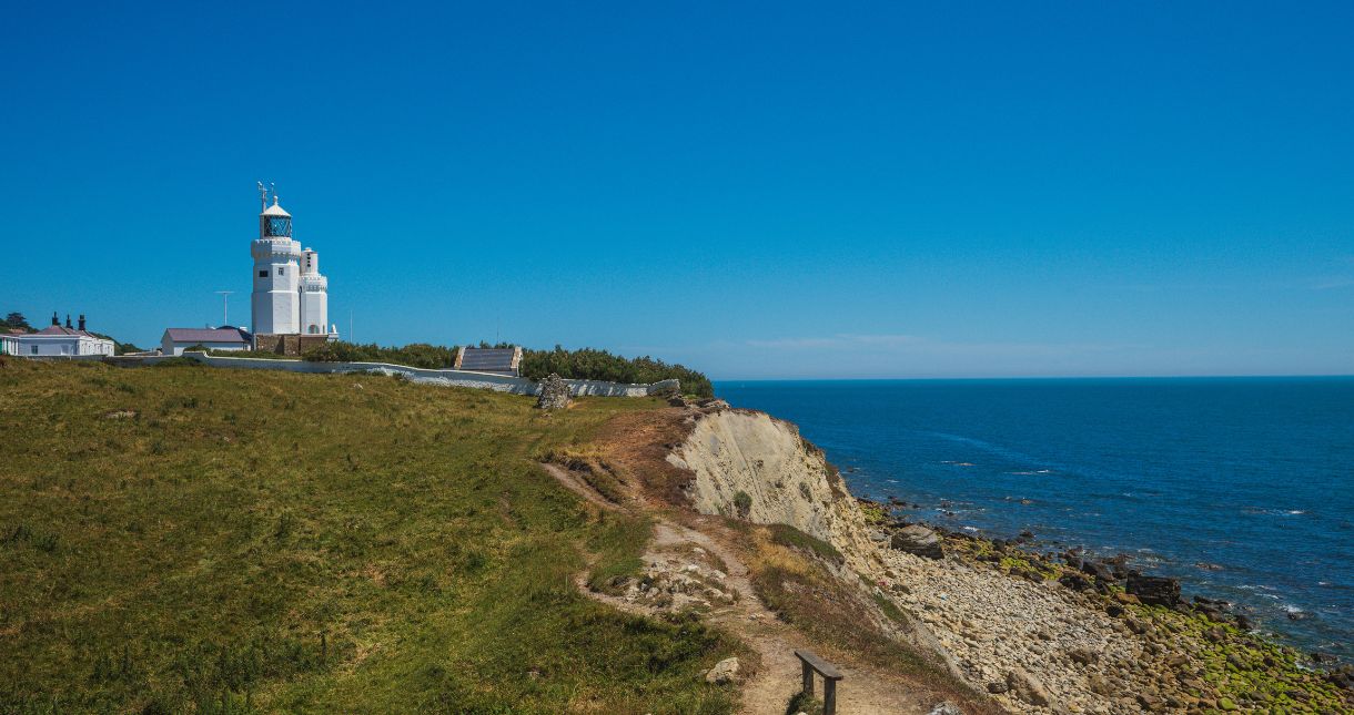
St Catherine’s Lighthouse
Just five miles from Ventnor, at Niton Undercliffe, you can find St Catherine’s Lighthouse.
Constructed as a 40m high stone tower in 1838, it was subsequently shortened by 13m in 1875 as it was often obscured by fog. St Catherine’s Lighthouse was built following the loss of The Clarendon ship on the hidden rocks near its location.
Maintained by Trinity House, it’s the third most powerful lighthouse in the UK with a range of 25 nautical miles (equivalent to 46km or 29 land miles). The white octagonal tower has 94 steps up to the lantern and an adjacent tower built in 1932 that used to house the now redundant fog signal. The lighthouse has its own tragic story as a bombing raid destroyed the engine house in June 1943, killing the three keepers on duty.
Automated in 1997, the lighthouse is now monitored and controlled from the Trinity House Operations and Planning Centre in Essex.
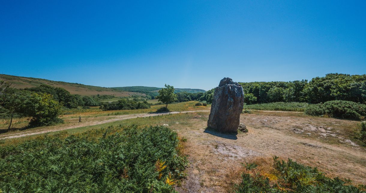
The Longstone, Mottistone
The only Neolithic monument on the Island, local legend has it that St Catherine and the Devil himself created The Longstone as they fought over the Isle of Wight. During their struggle, St Catherine threw a four-metre-high stone from the nearby Down that bears her name and lodged it decisively into the ground in Mottistone. The Devil threw a smaller stone that landed short of St Catherine’s, giving her a clear victory of good over evil.
The stones are believed to be the remains of a 6000-year-old communal long barrow, used for burying the dead. Bodies were laid out for birds and animals to pick clean and then the bones were buried in chambers with earth piled up on top to form the distinctive dome shape.
It’s likely the stones were moved in Saxon times and they definitely were moved in the 19th century by Lord Dillon, a local squire who wanted to know what was beneath them. He found nothing, but pottery excavated in 1956 indicates that the mound, and therefore the stones, are Neolithic.
Modern-day pagans still meet at The Longstone throughout the year to celebrate notable dates, including the Summer Solstice. The site is looked after by the National Trust and is free to visit and is a well-trodden route for dog walkers and hikers.
.jpg)
Yarborough Monument
Another imposing landmark to visit is the Earl of Yarborough Monument on Culver Down.
The tallest monument on the Island, it’s a striking part of the skyline for the east of the Island and is used as a seamark for shipping.
The monument was erected to commemorate The Earl of Yarborough (1781-1846) who was born Charles Anderson Pelham in Lincolnshire. Born into a very powerful family, he inherited by marriage the estates of Sir Richard Worsley who was the largest landowner on the Isle of Wight, whose estates included Appuldurcombe, once the grandest house on the Island.
Charles was to make his mark firmly on the Island due to his love of not only Appuldurcombe but also of sailing. He was one of the founders and later became the Commodore of the Royal Yacht Squadron in Cowes – arguably the most prestigious yachting club in the world.
Three years after his death, the Yarborough monument was built on the higher summit of Bembridge Down. It was painstakingly moved in the 1860s to make way for Bembridge Fort, built as part of the Island’s defences against invasion. Easily accessible by walking, it’s definitely a landmark to tick off the list when visiting the Isle of Wight and you’ll marvel at the view out across Sandown Bay and there is also a cosy pub to visit after your bracing walk.
.jpg)
Tennyson Monument
An imposing monument to Alfred, Lord Tennyson, Queen Victoria’s Poet Laureate and great exponent of the Isle of Wight, stands at the highest point on Tennyson Down (formerly known as High Down).
Designed by JL Pearson, it was built in 1897 from marble by Farmer & Brindley and erected in the place Tennyson loved best. He used to walk on the down almost every day during the years he lived on the Isle of Wight, saying that the air here was worth “sixpence a pint”.
Although Tennyson is buried in Westminster Abbey, his heart lay with the Isle of Wight. He lived at Farringford in Freshwater. Originally renting the house, he fell in love with the area so much that he bought it in 1858. He wrote Charge of the Light Brigade and much of his oeuvre on the Island, having been inspired by the magnificent scenery.
Enjoy the steep climb and stunning views across the western peninsular and out across the English Channel as you head towards the monument, or it is more easily reached from the Highdown Inn just outside of Totland where steep steps provide a quicker approach.
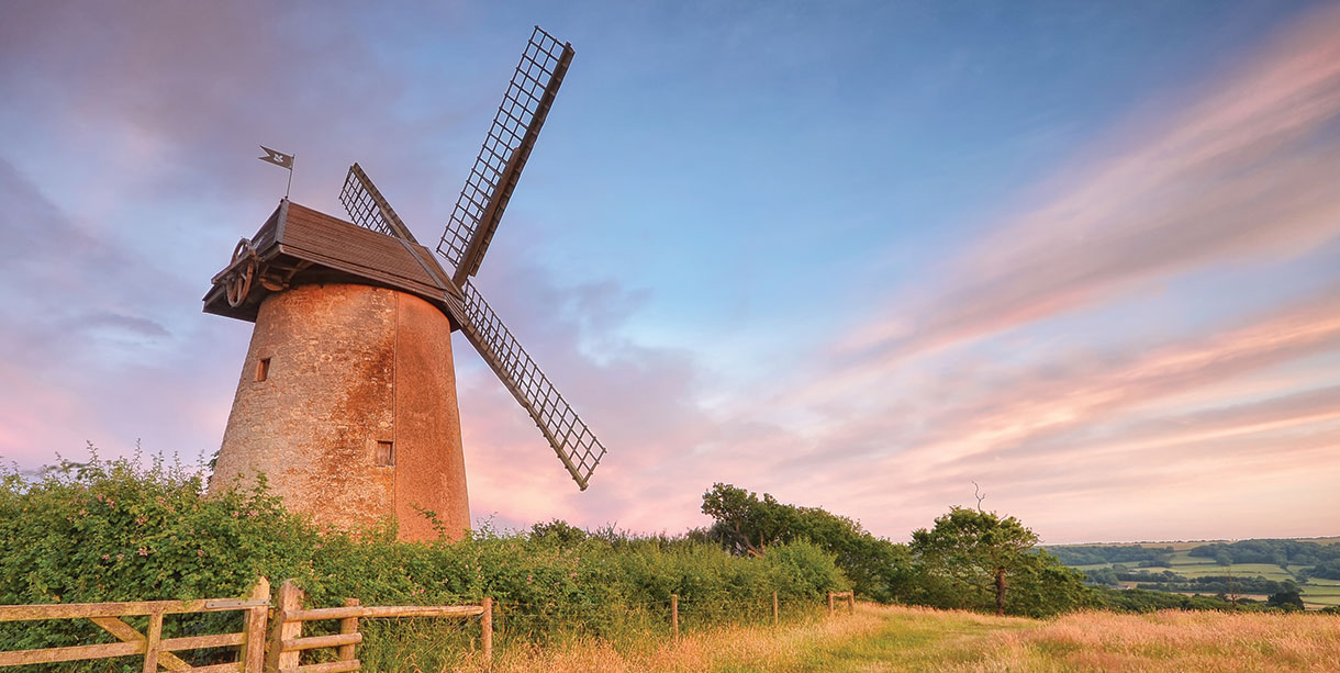
Bembridge Windmill
Owned by the National Trust, Bembridge Windmill is a Grade I listed building which was built around 1700 and is the only surviving windmill on the Island. Much of its original machinery is still intact over its four storeys, which you can access by some rather steep steps. Fully operational during Queen Victoria’s reign, it only closed down in 1913, making it an excellent example of the way people lived and worked in the 19th and early 20th centuries.
Visitors can discover how the windmill worked and marvel at the view that inspired painter JMW Turner where you can see a print of this unfinished work in the windmill kiosk. Make the most of your surroundings - you might decide to explore the Culver Trail which surrounds the windmill. There are some of the most beautiful walking trails around this area for serious walkers and casual strollers alike. If you’re on your bike there’s a clearly marked Island Cycle Route through the centre of the village past Bembridge Windmill and to nearby Bembridge Fort.
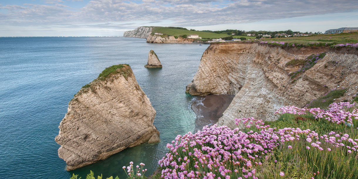
The Mermaid and Stag Rocks at Freshwater Bay
There are local legends galore in Freshwater Bay, thanks to its rich history of smugglers, pirates and shipwrecks. Famed for its geology and coastal rock formations, as well as its picturesque beach just south of Freshwater itself, Freshwater Bay is a hugely popular spot. Any time of year, the bay has stunning views, with big breaking waves and sea foam.
Looking from the beach, there are various rock formations that form natural landmarks. One of the best-known was the Arch Rock before it collapsed in a large storm in 1992. The chalk rocks of the cliffs are under constant attack by the waves crashing against and underneath them. Still standing is Stag Rock – a column that is named for a stag that supposedly leapt to the rock from the cliff to escape the hunt. This has also changed in recent years, with a large slide taking off most of the face back in 2021.
Another huge slab fell from the cliff face in 1968 and is known as Mermaid Rock, as it forms the perfect base for mermaids to lay back and enjoy the sunshine (there haven't been any confirmed sightings as yet…) Just behind is a big sea cave going several metres into the cliffside - smugglers once used these caves at the bottom of the chalk cliffs that are exposed at low tide. However, it’s not advisable to explore alone or without an expert guide as you can be cut off by the rising tide. Kayaking or paddleboarding is a great way to see them as well as other, smaller bays that are also carved from the chalk cliffs.
Appuldurcombe House and Freemantle Gate
Only a beautiful ruin stands today, but Appuldurcombe House in Wroxall was once the grandest house on the whole of the Isle of Wight. The seat of the infamous Worsley family, the house began life as a priory back in 1100. It was later converted to a convent, then a home to the Leigh family during Elizabethan times. The present Appuldurcombe House was built in 1702, replacing the large Tudor house, which was then given to Sir Robert Worsley, 3rd Baronet. In 1779, Capability Brown was hired to design the grounds.
The mansion was severely damaged during the Second World War by German bombers. A German bomber dropped a mine close to the mansion. Today, although some of the front portions of the mansion have been repaired, it is still predominantly an empty shell.
Despite having many owners over the years, the one with the most notoriety remains Sir Richard Worsley, when in a 1782 court case, his wife, Seymour, admitted to having had 27 lovers.
The house itself often forms part of the many ghost stories told on the Island - visitors have reported seeing a phantom carriage near the ground’s entrance and monks in their traditional brown clothes. The sound of a crying baby has been heard throughout the house too. Today it is owned and managed by English Heritage and is free to visit.
Just up from Appuldurcombe and forming part of the state is the Grade II LIsted Freemantle Gate, an ornamental gateway to the mansion. This imposing feature was built from Isle of Wight stone ashlar with Portland stone dressings and cast iron gates. Now it is used by pedestrians and farmers.

 to add an item to your Itinerary basket.


.png "Isle of Wight")


like, follow, share....join in!
Facebook
Twitter
Instagram
YouTube
TikTok
Threads