
 to add an item to your Itinerary basket.


Our island is a pocket-sized paradise where stunning scenery meets surprising accessibility. Whether you’re pushing a buggy, using a wheelchair, or just fancy a gentle stroll without the steep climbs and rocky scrambles, this island’s got your back.
In this blog, we’re taking you on a tour of 10 of the most accessible walking routes across our island, all chosen for their ease, beauty, and that all-important feel-good factor. From coastal boardwalks with sweeping sea views to woodland trails where bluebells bloom and birds sing, these routes prove you don’t have to hike up a mountain to enjoy the magic of the outdoors.
So grab a flask, pack a snack, and let’s hit the paths – adventure is just a gentle walk away!
1. Ryde to Seaview via Appley and Puckpool
- Terrain: Paved/tarmac, smooth, slight inclines.
- Distance: 2.5 miles (out and back)
- Time: 1 hour
Summary:
One of the most popular beaches, the beautiful golden sands run for over a mile along the North-East coast of the Island with an accessible route along the sea wall.
Route:
Starting on the North Walk, you can park up in the pay and display bays (parking charges apply) or take the number 2, 3, 4, 8 or 9 to the Ryde Transport Interchange, then head eastward along the sea wall.
Ryde has an accessible beach, with changing facilities, a purpose-built boardwalk, 4 step free entry points and beach equipment available to hire for free. Visit Ryde Beach Accessibility for full information and to book equipment.
Early in the walk, the sea views are obstructed by the large sea wall however, if you’re longing for a view of the sea, this obstruction doesn’t last the duration of the walk and after a few minutes, you’ll find the beauty of the beach and sea comes into view.
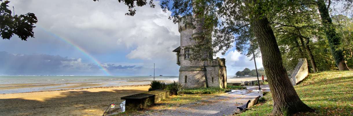
Along the Appley – Puckpool section of the beach are 2 cafés, a children’s play park, the gothic Appley Tower and (at low tide in particular) acres of sandy beach! Step free access is limited to the western end, however there is a paved pathway that sits atop the sea wall and runs the length of the beach. There is a small section around the Puckpool Battery (Appley Walk) which can be wet at high tide and in stormy conditions, so extra care should be taken if travelling at these times, however in fine weather, this section is shady and offers a more peaceful rest stop from the busy beach.
Top tip: Pop into The Boathouse restaurant at the far eastern end of the beach for a quick tipple before making your way back.
Want more of a challenge? Extend this route by heading East from The Boathouse and either join the Hersey Nature Reserve walk (mentioned below) or continue on to the seaside village of Seaview and the secluded Seagrove Bay. (This route adds up to 3 miles to the round trip.)
2. Sandown to Shanklin
- Terrain: Paved/tarmac, smooth, flat.
- Distance: 6.5 miles (out and back)
- Time: 2.5 hours
Summary:
A long, flat route that runs the full southeastern coastline of the Island, with accessible beach locations, attractions and cafés.
Route:
Starting and finishing at Yaverland Beach, you can park in the public car park (parking charges apply) or get off the number 8 bus at Wildheart Animal Sanctury or Meadow Way and stroll down the flat paved promenade while watching the tide ebb and flow.
There is step free access to the beach at numerous points along the route, and Sandown is an accessible beach with changing facilities, free to hire equipment and matting which is rolled out in the summer months. Visit Sandown Beach Accessibility for more information.
An iconic stretch of the island’s coastline, there are numerous cafés and rest stops along the route, with accessible toilets located on both Sandown and Shanklin seafronts. This route also features numerous amusements and attractions at both ends including, Wildheart Animal Sacntury, Sandham Gardens, the historic Sandown Pier, and Shanklin Chine
Due to it’s proximity to the beach, the section between Sandown Pier and Shanklin Esplanade can be wet at high tide and in rough conditions, so extra care should be taken if travelling at these times.
Top tip: If you’re an early riser, this is one of the best places to for a morning stroll with a coffee while watching the sun rise.
Want more of a challenge? When you reach Shanklin, you can walk up Hope Hill, then turn right onto Delphi Rd and take the clifftop footpath back into Sandown.
3. Ventnor to Bonchurch
- Terrain: Paved/tarmac, smooth, slight inclines.
- Distance: 2 miles (out and back)
- Time: 45 mins
Summary:
A short, mostly flat route which Victorians used to tout as good for the constitution with fresh air and a sea breeze.
Route:
Park on the seafront (parking charges apply) or get the number 3 or 6 bus to Boots and walk down steep but iconic cascade to start at the famous Ventnor Paddling Pool, shaped like the Isle of Wight. Public toilets are available at either end of the route, however there are no accessible toilets on this route.
Heading east from Ventnor, this route across the sea wall follows a meandering path around some of the striking cliff faces the south coast of the Island if known for. With slight inclines, but a smooth surface, this easy route is ideal for an afternoon stroll. With uninterrupted views of the English Channel, you can always see large ships on the horizon, making their way into Southampton or Portsmouth, or onwards to northern European destinations, as well as the occasional local fishing boat leaving Ventnor Haven.
On the return section from Bonchurch to Ventnor, you can follow the Solar System Walk. Laid out on a scale of 1 inch = 100,000 miles, you can travel from the Sun to Pluto, at a much easier and relaxing pace! With information along the route, you really get a sense of the enormous size of the solar system and by the time you reach Pluto, you will be unable to see the sun!
Unfortunately, there is no beach access along this route due to the large sea defences set up to protect the cliffs from erosion.
Top tip: Ventnor Haven Fisheries open daily with freshly caught local produce available or continue onto the main esplanade to enjoy refreshments at one of the cafés or Spyglass Inn.
Want more? Continue along the esplanade, up the hill and through the car park and you can follow a tarmacked section of the coastal path up to the hillside VENTNOR sign where the white letters are over 10ft high and can be seen out at sea. (This addition adds 1.2 miles to the round trip.)
4. Appuldurcombe House to Freemantle gate
- Terrain: Mixture of tarmac and gravel/offroad track, bumpy in places, slight inclines.
- Distance: 1 mile (out and back)
- Time: 30mins
Summary:
This hillside walk features stunning views of Wroxhall and you can even catch glimpses of Culver down.
Route:
Park at Appuldurcombe House (free car park open 10:00 – 16:00, Sunday – Friday, April – October) and walk up along the tarmacked road opposite the Main House. When the track turns left to head up to the farm, continue straight through the farm gate and follow the unmade path along the hilltop.
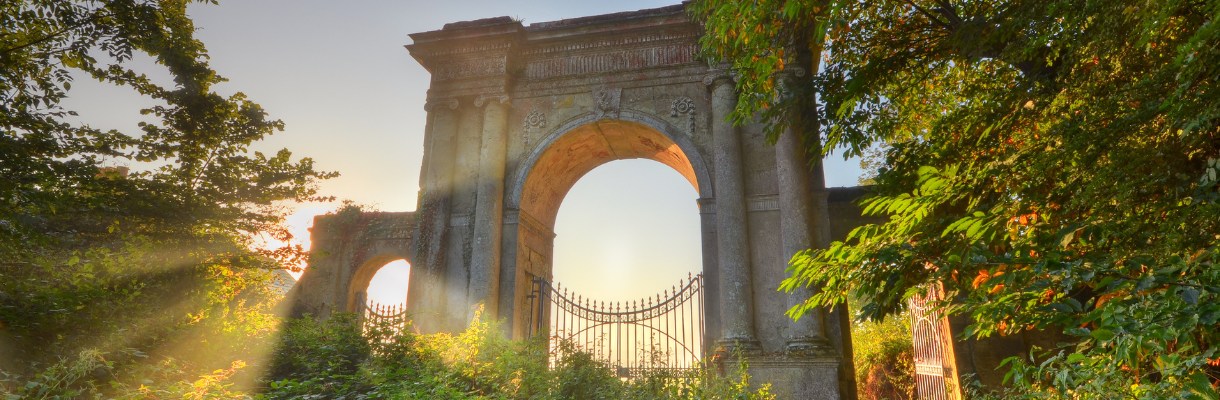
At the end of the path is the imposing Freemantle Gate which used to serve as the gatehouse for Appuldurcombe estate. No longer used for this purpose, the smaller side gates remain open for pedestrian use and allows access to Godshill via Godshill Park Road.
Still working farmland, there are often flocks of sheep in the main field on the way to Freemantle Gate so if you are taking dogs along this route, it is recommended they remain on lead and under control at all times.
Be aware there are no rest facilities available on this route at any point.
Top tip: If visiting between April – October, be sure to pop into Appuldurcombe House. This 18th century country house was bombed heavily during WW2 and is free to explore thanks to English Heritage.
Want more? Head through Freemantle Gate and down Godshill Park Road, then turn left at the main road to visit the small but busy village of Godshill with attractions and places to eat and drink. (This addition adds 2 miles to the round trip.)
5. Red Squirrel trail (Merstone to Blackwater)
- Terrain: Mixture of tarmac and gravel/offroad track, bumpy in places, slight inclines.
- Distance: 4 miles (out and back)
- Time: 1.5 hours
Summary:
As part of the Red Squirrel Trail, as the name suggests, this route is a hotspot for the Islands native but illusive Red Squirrels as well as plenty of other wildlife.
Route:
Starting at the Merstone end of the Red Squirrel trail, either park in the free to use car park or get off the number 2 bus at Newlands, then head in the opposite direction to the road along the track. At the end of the track, turn left onto the unmade farm track, then follow the signs for the cycle route. One you get to Blackwater Hollow and the garage, turn round and head back.
There are no public restrooms on this walk so make sure you are prepared, but you can stop at Naturezones where they have a small café, shop, rest facilities. They also feed the local Red Squirrels here so this is the best place to see them.
There is a small section of the walk in the middle, which is along an active, unmade track so be aware of farm traffic, but both ends of the walk are smooth and tarmacked. This route is also commonly used by cyclists so be aware when undertaking, especially at the weekends and during commuting hours.
Top tip: Part of the old Island railway line, the start point was the location of the Merstone station. The platform is still there for you to walk along and a picnic area has been added so be sure to take some snacks!
Want more? Blackwater Hollow is a busy road, but if you cross it, you can continue the old train line into Newport via Shide. This route is unmade and very rough in places so only undertake with the appropriate equipment. (This addition adds 2.4 miles to the round trip)
6. Island Harbour to Seaclose Park
- Terrain: Gravel/offroad track, bumpy in places, slight inclines.
- Distance: 3 miles (out and back)
- Time: 1.25 hours
Summary:
A quieter and more picturesque trip down the river medina than the western side, this route travels down the edge of the Isle of Wight Festival site so is closed to the public around the festival in June.
Route:
Park in the harbour or get off the number 5 or 9 bus at Whitehouses or Binfield Corner and walk down the road, and walk towards the river. The public footpath N120 starts right at the waters edge, and this is the route to follow the whole way. At the end of the footpath is Seaclose Park with public restrooms, tennis courts, a skate park and children’s play area behind the bowls club and garage. You can also follow a path through the arboretum to Medina Leisure Centre.
This route runs parallel to the Cowes – Newport cycle track however is much quieter and relaxing to go along. The pathway is gravel with a plastic membrane so is relatively smooth and flat, although there are sections of incline.
If you can’t make the walk back, just head to the top of the hill and get on the bus at the garage and get off at the start point.
Top tip: Taka a camera and capture some pictures of the riverbank wildlife or time the walk right and return to the harbour at sunset for a beautiful view of it through the yacht masts.
Want more? Whilst this is an out and back route, the mid-point is half a mile from Newport Town Centre so it is very easy to carry on into town for foot, rest facilities and shopping, then turn back or catch the number 5 or 9 bus back to the start.
7. Ryde to Quarr
- Terrain: Paved/tarmac, smooth, slight inclines.
- Distance: 3 miles (out and back)
- Time: 1.25 hours
Summary:
A well-used weekend route for locals, this paved bridleway route heads to the only monastery on the Island, which has ruins dating back to the medieval period.
Route:
Get the 4 or 9 bus to St Vincents or park up at the end of Ladies Walk and head through the white gate between Ryde Golf Club and grounds. Halfway along the path, you can pop down a footpath on the right-hand side and onto Binstead beach to watch the Wightlink ferry going in and out. At the end of the footpath, pass the Holy Cross Binstead Church then keep right to stay on Church Road. Bear right onto Bridleway R45 Quarr Abbey then bear left and follow footpath before turning right to head along Quarr Road and onto the monastery.
There are no facilities available at the start of the route, however the abbey has a café and accessible rest rooms available. At various times throughout the year, they also have pigs and piglets in their courtyard and you can buy bags of feed to give them.
Quarr Abbey is an operational catholic benedictine monastery, so can be busy at the weekends with Sunday services, but large parts are open to the public for quiet contemplation and prayer every day.
Top tip: Keen on sustainability, the monks grow and sell their own fruit and veg produce and even make their own ale and cider which you can purchase too! If you can’t make the route back, follow the main drive to the road and jump on the number 4 or 9 bus back to the start.
Want more? Continue along the main footpath for 10 minutes to Fishbourne and watch the Wightlink ferries going in and out from the beach or grab something to eat and drink at The Fishbourne.
8. Western Yar footpath
- Terrain: Mixture of tarmac and gravel/offroad track, bumpy in places, flat.
- Distance: 3.6 miles (out and back)
- Time: 1.5 hours
Summary:
Following a section of the old railway track, this route follows the River Yar into Freshwater next to undisturbed marshland rich with birdlife.
Route:
Starting at River Road car park (parking charges apply) or getting off the number 7 bus at Yarmouth station and heading south, follow the pathway along the riverbank and past the old mill. Stay right where the main pathway joins and keep going with the river on your right. Once you reach the bridge that crosses the river, turn round and head back the way you came.
Near the start point in Yarmouth there are toilets, shops, cafes and restaurants however there are no public facilities at the turning point, however if you cross the bridge you will find the Red Lion pub.
This route follows the old train line and is a mixture of paved and gravel but is smooth and flat. On your return, keep right at the old mill and you’ll soon arrive at Off the Rails — a charming café housed in the former railway station.
Top tip: Head over the bridge at the mid-point and pop into the Red Lion, a Michelin listed pub or visit its sister pub, the Wheatsheaf Inn in Yarmouth, near the start point.
Want more? At the end of the walk, instead of heading back to the car park, keep right at the old mill and explore more of the pathway along the marshland before turning back. (This addition adds 1.2 miles to the round trip)
9. Colwell to Totland
- Terrain: Mixture of tarmac and gravel/offroad track, smooth, moderate inclines.
- Distance: 1.5 miles
- Time: 30 minutes
Summary:
One of the only beach promenades on the West Wight, the path was re-routed after a section of the old sea wall collapsed in 2012.
Route:
Park up at Colwell Bay car park (parking charges apply) and head towards the beach to get started. Whilst this is not an accessible beach, there is step free access onto the sand at this point. Whilst there are accessible toilets available here, there is a small charge for using them.
Head left at the beach along the sea wall and continue past The Hut, round the headland and on to Totland Bay. You’ll be able to see where the old sea wall fell away and this is where the path temporarily changes from paved to gravel. Go up and over the landslip and you’ll soon be back on original sea wall path.
Unfortunately, there is no step free access onto Totland Bay beach however at high tide you can see the crystal-clear waters as you travel along the sea wall along to the old lifeboat station before turning back.
Top tip: This section of coastline is famous for its stunning scenery, calm water, and beautiful sunsets in the summer - many locals liken Totland Bay to the French riviera, as the setting is idyllic and luxury yachts can often be seen moored up.
Want more? There are places to eat at either end of this route. Coupled with the amazing sunsets – it’s best to book to avoid disappointment (you can even arrive by boat to The Hut!)
10. Hersey Nature reserve
- Terrain: Gravel/offroad, smooth, flat.
- Distance: 200 meters
- Time: As long as you need.
Summary:
This relaxing nature reserve is the calmest and most accessible on the Island with flat gravel walkways.
Route:
Park up at the Duver long stay car park (parking charges apply) and cross the road into the nature reserve.
There are no facilities at this site so be sure to come prepared.
Top tip: Beautiful any time of day, you can sit in the bird hide and look across the marsh as long as you want.
Want more? The Boathouse is a short walk away if you head towards Ryde or pop into Seaview.


.png "Isle of Wight")


